+91 9884683139
talk to our Destination
specialist
A land engulfed in mystery, inhabited by vibrant people zealously guarding their culture – dancers, warriors, head-hunters; mountains, valleys, forests – all these form the portrait of Nagaland the moment the word is uttered. But, from extreme mystery to hosting a globally famous cultural festival, Nagaland has come a long way over the years and etched a name for itself in the world’s tourist destination map.
Nagaland shares her borders with Assam in the North and West, Myanmar and Arunachal Pradesh in the East and Manipur in the South. The topography of the state is nearly all hilly, the highest peak being Saramati (3841m) in the district of Kiphire. Many rivers cut through this mountainous terrain, like sharp swords slicing through rocks, the main ones being Dhansiri, Doyang, Dikhu, Milak, Tizu and Zungki.
Colourful costumes, spicy cuisines, pleasant weather, traditional villages, beautiful dance forms and lyrical songs are all that define the north-eastern state of Nagaland.
Encompassing hills, mountains, plains and plateau, the region has many cultural groups and communities with varied cultural background and biodiversity hotspot where it lies which can easily attract tourists from the world over.
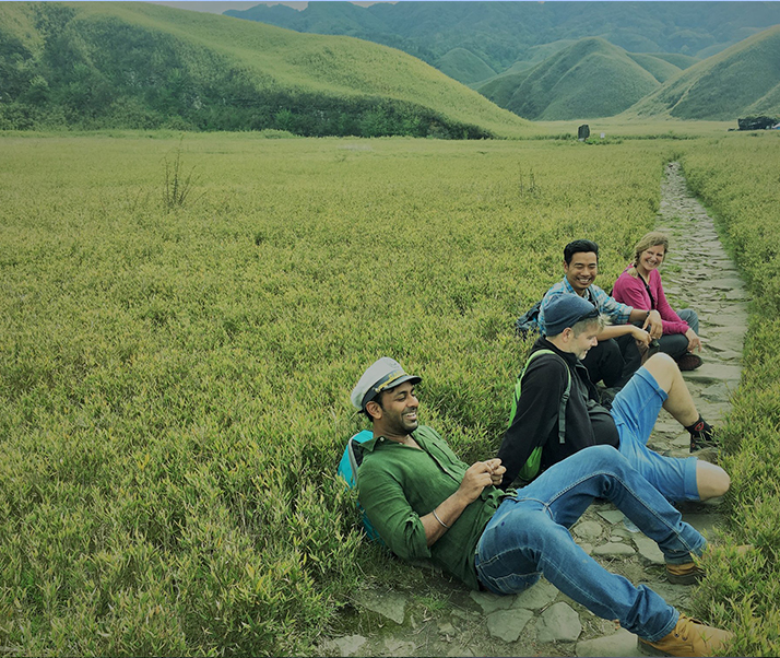
Life in rural areas is extremely engaging, more colourful and unusual compared to what travellers are used to seeing. The scenery is equally engrossing.
Summer sets in the month of March and continues through end April / start of May. Temperatures vary depending upon the altitude of the area and the district. Unlike the rest of the country, summers are humid but moderately hot. Monsoon is quite prolonged in Nagaland lasting from May to September. The state experiences medium to heavy showers during these months. Winter in Nagaland is extremely pleasant and beautiful. Humidity is at its lowest; temperatures are low and are great for moving around and exploring the different areas. As you go higher up temperatures continue to fall and can dip as low as 4°C.
Key Facts
Mar - Apr: Min: 16° C / Max: 31° C
May - Sep: Min: 20° C / Max: 30° C
Oct - Feb: Min: 4° C / Max: 20° C
The Land of the Nagas!!
Kohima is the hilly capital of Nagaland, which is one of the seven sister states of India. ‘Kohima’ is the anglicized name given by the British, the original name being 'Kewhira' derived from the Kewhi flowers found in the region.
Famous for its ethereal environment and untouched beauty, it is a land of folklore passed down through the ages. Situated at a height of 1500 metres above the sea level, it is endowed with quaint hills, emerald forests and a picturesque landscape.
Kohima was built by the British and is home to the Naga and Kulkis tribe who can amaze one with their independence and a mystical and colourful culture that surrounds them. Kohima finds its place in history as the site of an intense fight with the Japanese, a part of a 64 day long battle during the World War II. One of the most popular sits here include the Commonwealth War Cemetery which homes thousands of soldiers of the World War II. Other than that, the city has a lot more to offer to its visitors - a museum, zoo, sanctuary, valleys, self governing villages and much more.
The Gateway to Nagaland!!
Dimapur is the ancient capital of the Kachari tribe, whole rule existed before the 13th century AD. Reminiscences of the glory of this kingdom can be found on the ruins that are scattered..
in and around the town. The Dhansiri river flows past the city. The word Dimapur is derived from the Dimasa word, ‘Di’ meaning water, ‘ma’ signifying big or great and ‘pur’ meaning city. Thus, Dimapur means the city by the great river.
Some of the few attractions here are: Triple Falls, Kachari Ruins, the Nagaland science center and the zoological park.
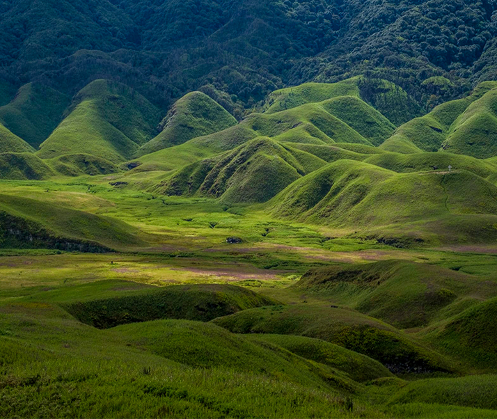
Valley of Flowers of the East!!
Located some 25 km south of Kohima, Dzukou valley and Japfu Peak offer one of the most breathtaking landscapes of the continent and is an absolute must for all trekking enthusiasts.
The Japfu Peak standing tall at 3048 meters is the second highest peak in Nagaland and provides the perfect vantage point for admiring the heavenly beauty of the Dzukou Valley. Dzukou valley is quite a sight to behold, when in full bloom. Dzukou Valley is considered to be the base of the crater of an old volcano and seems like covered with a carpet of the most exquisite species of grass and flowers.
The highest point in the Dzukou valley is at 2600 meters and provides a wide and panoramic view of the enchanting valley in the front. Sitting atop the hill you are just overwhelmed by the sheer beauty and magnificence of the sight in front of you.